California has experienced six of its most destructive wildfires in just 10 months. The fires have charred more than 10,000 structures and claimed dozens of lives. The Carr Fire near Redding has joined five other large fires since Oct. 2017 on the state’s 20 most destructive wildfires list. As of Friday night, the Carr Fire had destroyed over 1,500 structures and killed six people, ranking as the sixth most destructive wildfire.
Last December’s Thomas Fire and four wildfires from October 2017 – Tubbs, Nuns, Atlas and Redwood Valley – are also on the top 20 list.
These six wildfires have destroyed 10,966 structures and killed 48 people. The Tubbs Fire in Sonoma County last October is the worst of them all, accounting for 5,636 of the destroyed structures and 22 deaths.
California is prone to wildfire activity from summer into fall since vegetation is dry. Little rain falls in much of the state during the so-called dry season from late spring through summer.
October’s intense wildfires were fed by the Golden State’s second-wettest winter (Dec. 2016-Feb. 2017) and then its hottest summer (June 2017-Aug. 2017). The vegetation that grew in response to the wet winter quickly dried out months later and provided fuel for wind-driven wildfires to burn in the fall.
This summer’s wildfires come on the heels of California’s second-driest winter (Dec. 2017-Feb. 2018) and persistent warmer-than-average temperatures.
Many cities in California are experienced one of their hottest Julys on record. Redding had its third hottest July on record.
Because of this, vegetation moisture is at record or near-record lows for late July in parts of the state, according to Dr. Daniel Swain, a UCLA climate scientist.
Following weeks of below-average tropical activity in the eastern Pacific Ocean basin, Mother Nature has decided to add several tropical cyclones into the mix. This includes Hurricane Hector, Tropical Storms Ileana and John, and Invest 94E. The eastern Pacific Ocean, a region that typical experiences 15 named storms, 9 hurricanes, and 4 major hurricanes (category 3-plus), has already had 10 named storms, 4 of which have become hurricanes and all but 1 intensifying into a major hurricane. That makes the season so far above-average in terms of both ACE (Accumulated Cyclone Energy) as well as the pace of these named storms.
Typically, the 10th named storm does not arise in this basin until September 1. and the 4th hurricane until August 12. What’s most remarkable is how strong some of these storms have been thanks to the above-average season surface temperatures, unlike in the Atlantic Ocean. Three hurricanes (Aletta, Bud, and Hector) have all reached major hurricane status.
Wow 

Check out Hurricane Hector, category 4 with wind gusts to 280 km/h, as it makes its way across the central North Pacific.
The storm is expected to pass south of Hawaii on Thursday (NZST). pic.twitter.com/zsOIoY4Xx9
— NIWA Weather (@NiwaWeather) 6 août 2018
Hurricane Hector:
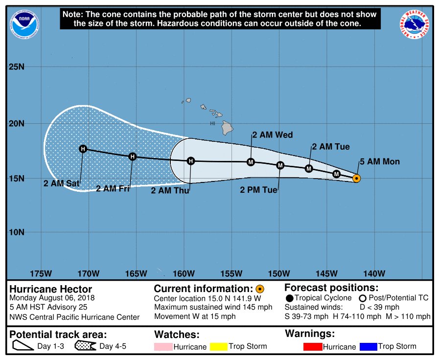
Following a scare late last week, Hector will not take a direct path toward Hawaii. Nonetheless, many of the islands will still be impacted by this storm in the form of gusty rain showers as well as rough surf and rip currents.
The size of this storm is massive as it tracks about due-west along approximately 15°N latitude. As of Monday morning (local time), the storm has reached maximum sustained winds of 145 mph, which is category 4 strength. It will take a slight turn to the north through midweek as it makes its closest approach to Hawaii as a major hurricane on Wednesday into Thursday, but again will remain well offshore.

Hector is forecast to hold at hurricane strength — albeit weaker once it moves west of Hawaii — as it continues to track west and possibly across the International Date Line by early next week, making it a typhoon.
Tropical Storm Ileana:
Ileana, an intense tropical storm, continues to hug the western Mexican coast while being located not too far from Tropical Storm John. Unlike Hector and the other active tropical cyclones in the eastern and central Pacific Ocean, Ileana will pose a direct threat to land, with Manzanillo and Puerto Vallarta as well as the southern extent of Baja California all in range.
Thanks to a conducive environment consisting of warm ocean temperatures and light wind shear, Ileana is expected to intensify into a hurricane as soon as Monday afternoon while tracking to the north and west, parallel to the Mexican coastline.
Tropical Storm John:
John, located about 300 miles off the western Mexican coast and about 150 miles away from the center of Tropical Storm Ileana, is forecast to intensify into the basin’s 11th or 12th hurricane, and the 4th major hurricane by Wednesday. Now while this storm will be stronger than Illeana, John will remain a safe distance offshore, allowing for minimal impacts as it also tracks north and west and parallel to the coast. Surf and the rip current risk will be slightly enhanced midweek. – NOAA
Invest 94E:
Last but not least, there is an invest in the eastern Pacific Ocean. This invest is basically an area of disturbed weather that the National Hurricane Center is monitoring for potential tropical development.
0 comments:
Post a Comment